The world is growing and about half of the global population of people is now living in cities — but how do you protect these growing cities from potential natural dangers such as earthquakes and the like?
Professor Xiaoxiang Zhu, who is lead expert of the study, and a team of scientists have discovered how to detect visual changes or early shifts in building and infrastructures as small as one millimeter per year, which, in a way, can help discover potential dangers such as a collapse of bridges, buildings, dams, or tunnels.
Zhu initially experimented the method in Las Vegas, Washington, Paris, and Berlin. “This growth places high demands on building and infrastructure safety, since damage events can endanger thousands of human lives at once,” the Professor for Signal Processing in Earth Observation at TUM said in a statement.
Views of the World’s Cities
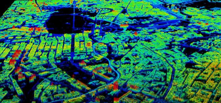
The German TerraSAR-X satellite, considered to be the most high-resolution satellite in the world, supplied the images and data.
Since 2007 the satellite has been orbiting the earth at 500 kilometers, sending microwave pulses to our planet and then receiving back their echoes.
“Initially these measurements are only in a two dimensional image with a resolution of one meter,” Zhu said.
She also worked together with the German Aerospace Center (DLR), which was responsible for using the satellite for specific purposes.
“The significance of the images is limited by the fact that reflections from different objects that are at an equal distance from the satellite will layover with each other. This effect reduces the three-dimensional world to a two-dimensional image,” said Zhu.
Zhu has indeed developed her algorithm, creating and reconstructing “four dimensional point clouds with a density of three million points per square kilometer,” which makes it easier to generate accurate four-dimensional city models.
Producing a Three-Dimensional Image
The images used by scientists were captured from slightly varied perspectives. The satellite flew over the region every 11 days, but not having the exactly the same orbit position, so as to localize each point in 3D space.
This was much like computer tomography, which provides a 3D look at the inside of the human body.
“Since this method processes only a poor resolution in the third dimension, we apply additional compressive sensing methods that make it possible to improve the resolution by 15 times,” said Zhu.
Scientists then can use these images to create three-dimensional buildings on earth, and can create replicas of buildings in Paris, Washington, Las Vegas, and Berlin.
Another Dimension
Since the images are taken at different times, scientists can now create a 4D model that shows tiny changes with accuracy.
Zhu further said, “The method is suitable for the detection of danger points. Satellite technology can thus make an important contribution to making our urban infrastructure safer.”
Forward looking, researchers plan to watch the world’s major cities grow.
In the ERC project “So2Sat” recently launched, global metropolitan cities are on the process of getting mapped out and observed on a long-term basis.
Their investigation focuses on newly industrialized cities known to have grown overnight.
Zhu and her team intend to use several Big Data sources to continue their observation.